Wednesday 27 October 2010

Updated route- Station map


And here are some minor changes to the more traditional metro map.
The major ones from the earlier version are:
[*] A kink in the track in the west end to get to the west edge of Scotswood (where redevelopment is taking place) rather than going straight to Lemington
[*] The blue line follows the yellow line to Byker rather than creating a new station along the mainline just a few metres north of it.

Monday 25 October 2010

Updated route- Geographic map


Excuse the uglyness of the map with all the random squares taken out of it but it was just too huge to post complete. I've even had to shrink it down quite a lot to get anything working!
Here is my proposed route on a geographic map. The stations are of course shown by the big over-sized yellow and black squares whilst the tracks are their route colours (with different shades for above/below ground).
Its somewhat rough but hopefully it'll give you a idea of the way things should be.
As I said back when I first started this the routes range from hard (the west end) to we should bloody well do this tomorrow (the blue line).

Sunday 23 May 2010

And...a more cut down commuter rail


As I mentioned many metro station should be skipped on the prior idea. Here is a more cut down and 'proper' version.
This still isn't the most conservative version (knock out Spennymoor and a few of the extra commuter stops in smaller places for that, e.g. Blackhall) but there we go.

I wonder what the final outcome will be when Blyth and Ashington finally do get their train stations.
It seems likely that Leamside will be reopened in Washington giving it a mainline train station too (unfortunately) so perhaps a single route which avoids Chester-Le-Street and the ECML and instead runs through Washington then onwards to either Sunderland or Durham and finally Boro?

Saturday 22 May 2010

Commuter Rail


As I've mentioned in prior posts there is a lot of talk these days about giving Blyth and Ashington rail links to Newcastle. Many (primarily from Blyth and Ashington) would like this to be a metro link however the distance involved is just too great for this to be viable. On the other hand, the distance is too short and the route too well used for just a regular train service.

So, here we have it, North East Commuter Rail.
Not actually a metro system however branded like one and with services more regular than a standard train (though nowhere near metro frequencies).

The map as presented here is very much one of 'maximum extent'. Not even ideal world but a map of where the lines should go.
Ideal worldly I would not service so many metro stations, they get good enough service already from the metro afterall and its unlikely many people travelling from Ashington will want to go to Newcastle residential areas. Only one or two of these outer stations should be serviced with the priority instead being to get to the city centre as fast as possible.

In addition to the Ashington-Newcastle link it also seemed to make sense to me to have better service linking Chester-Le-Street to Newcastle...and if you're going that far why not Durham? And from there it balooned into a north east wide network, linking up the Tees Valley metro and the Tyne-Wear metro.

Generally this map follows existing lines- sorry Blyth, but your town is just too far away from them and I had to serve the rim- however one small exception was made south of Durham for the large and unfairly isolated town of Spennymoor.

As I've said this is largely ideal worldly however the government does seriously want to build stations in Blyth and Ashington (and Washington but...that conflicts with my prior ideas and I've already established I don't like it!) and this seems the best way to do so.

A semi-metro...the bastard child of metro and rail.

Sunday 16 May 2010

Official word!


A departure from my normal posts here; some official news on metro expansions.
Sort of.
Project Orpheus seems to be getting a second wind. As found here (PDF) this image shows improvments the Metro managers would like to make. Given the new Tory government I'm doubtful of any of them coming true which is...not too massively dissapointing to be honestly. These improvments aren't great; just what is the obsession with trams?

Anyway. Lets have a look at what they want in no particular order. Little explanation is given in the document so this is largely just guess work on my part.

  • Superoute:
  • Despite the name this to me seems to be the most boring of proposals. Given that the superroutes run down to Stanley and Consett and the like this seems to be just a regular bus service. Perhaps just the already existing X busses, maybe an improvment on service with them.
    What is odd here though is that the super route is all that links Chester-Le-Street: despite this town being on the east coast mainline with its own train station. Why isn't Chester put in with the rail mentions?

  • Tram:
  • I do like trams in Europe, they're rather brilliant in cities like Amsterdam and Prague. Having had the misfortune of visiting Edinburgh many times in the past few years though I've grown rather against them in Britain. With roads not designed for them which also have to handle cars I have to wonder what is the point a little.
    The proposed tram routes here... well I must say I do love the little diversion down to Walker, this 'forgotten triangle' down my the river is something which could really do with service having missed out on the metro line. Given how hilly it is down that way a tram would be particularly nice and useful.
    The Metro Centre and Team Valley tram route is also interesting. Though I have to wonder here: Why don't they go with the rail route? The tracks are already there and the distance is a bit far for trams is it not?
    Newcastle West End- Well, it saves costly tunneling for a metro expansion and there are a lot of people here. A tram would be useful given that a metro expansion would be very costly and difficult. However the key question in my mind is based on my Edinburgh experience...Aren't the roads already a bit full and small up there? How will a tram be any better than a bus?
    Sunderland- The same comments as with the west end apply here. Service into the depths of the city would be great. With Sunderland I am most keen on the tram idea, they have a very underdeveloped part of the Metro network here and a tram could give the city good public transport for a cheaper price than a metro expansion (though I do still stand by my earlier proposed one!)
    What I do find very odd here in Sunderland though is that the tram seems to run from South Shields, along the railway/metro line and then follows the coast line down to Seaham. Why on Earth use a tram to replicate a already existing railway route here?
    One worrying possibility is they could be planning to downgrade the entire Metro system into trams. Which would not be good at all....
    Cramlington- See the latter parts of my Sunderland comments. They're essentially going over the east coast mainline with a tram here. Why? That it stops at Four Lane Ends rather than following the line into the city centre is encouraging here, it points away from a total conversion. But still...this route seems wrong.
  • Guided/Segregated Bus:
  • Ouch. Segregated. Blacks in the back!... Or probally not. But the name does seem to point that way. This probally means bus lanes and...well. Like everyone in the country excepting taxi and bus drivers I hate bus lanes.
    Guided bus on the other hand...I've never came across these before. The closest I've seen are those busses that run off tram cables in Geneva but that isn't waht this is at all. Rather it seems to be a bus that runs partially on a track and partially as a regular bus. Which is odd. Though intruiging as something to run partially on the existing system and then move off- this technology could be handy inside the eastern Newcastle loop. Here though the routes seem to be largely ignoring existing metro lines hence the question 'why?' appears.
    I've nothing too special to say on the routes here except that they seem to be using this to ignore Washington when it comes to the good stuff again.
  • Rail Developments:
  • Now this is interesting. A big question is though are these rail developments to the metro or just general national railway developments?
    A development of the line running west to the Metro Centre seems to be on, which is just great, it goes all the way to Prudhoe though, which given its distance would seem to suggest to me this is not the metro but rather just regular trains.
    In the north the much talked about passengerisation of the Ashington line is also on, again though I believe this has been talked about as a regular train route and not the metro.
    You never know though, this could be as part of a 'semi-metro' given the way they seem to be expanding into lots of other areas of transport.
    The one big oddity with this railway extension is rebuilding the railway on from South Hylton and into the fields towards Penshaw where it says 'possible connection to Leamside Line'....To me this seems to suggest the Leamside Line reactivation could already have been approved and be underway? Interesting but odd.

    Small changes


    So! Back to the Newcastle Metro!
    This has been a long time in the making due to life commitments more important than my strange little interest.

    There are very few changes to this map, just the addition of Ryton onto the blue line- whilst the blue line in general before was an 'easy extension' which just involved improving already existing railway tracks with a extra lane or two this addition involves a bit of actual new track. Though not much. Just a divergance from the Carlisle line to go closer to the town centre and give this large town access to the network.

    Also planned for this edit was incorporating the local railway into the map.
    I had the idea that local rail routes should be given far greater public attention, as things stand now its just as hard to get a train from Newcastle to Prudhoe as it is to go all the way down to London. These local routes should be given a unified branding and tied in very closely with the metro- all trains from Hexham, Pegswood and Ashington in should unquestionably be given this system. This would largely I'd imagine take the form of just better awareness and integrated pricing with the existing trains however for some routes a 'semi-metro' could be useful- with Ashington in particular I would lean this way, its a bit too far away for the proper metro however it does deserve regular service when it gets its railway connection opened.
    In the south this link should go to Durham at the least however the government has made many rumblings recently about a better north east railway line connecting Teeside and Tyne and Wear- this sounds good to me so I would also integrate to a degree down to Middlesbrough on both the Durham-Darlington-Boro line and the Sunderland-Peterlee (which needs a station! That a town this big on a railway line doesn't is very odd)- Hartlepool-Boro line.

    Friday 5 March 2010

    Teeside Metro 3: Thinking ideal worldly

    Adding on from the last post; what if we were to try and make a 'real metro' in the Middlesbrough area?
    This is of course purely ideal world, blue sky thinking and is never going to happen but nonetheless....

    This proposed greenline will aim to link in the suburbs of Middlesbrough/Stockholm which would otherwise be without rail transport and such is using new lines. These lines however are all above ground with there being no immediate need for tunneling.

    Inglesby Barwick

    The line will start/end somewhere around this large estate in the south west. Depending how extreme we want to be there could be two stations; one towards Yarm on the south end of the estate then one more towards the north east of it; or just the one station, likely located on the east.
    It could even be that we may need three stations with two on the east or just two stations on the east. This is a large estate surrounded by a fields.
    I will be going with the simplest, one station option with the station placed towards Ingleby Way.

    South Thornaby

    Cutting along by the A174 between Thornaby and the industrial estate we have a good location for another station. Its very far from Thornaby station proper.

    Hemlington

    After a large greenfield area we then reach Hemlington/Acklam. I would plan to cut between the two following the A174's green shoulder to avoid having to do any tunneling through built up areas.

    Acklam

    I would place the next station east of St.Mary's college after some major golf course avoision. This station again has a large residential capture area and is far from the railway line proper.

    After Acklam we then head east to join the mainline just south of the proposed hospital station. We then follow this up through the city centre and westwards until we reach the northbound part of the journey....

    Hartburn

    With the Fairfield route we have two possible alternatives.
    1: Loop around the western edge of the estate.
    2: It seems there is a disused railway alignment (currently sans tracks) running right through the centre of the built up area. If we could follow this catchment would be amazing.

    I will assume 2 is possible (this is ideal world thinking afterall) though 1 would not be too much different.

    The Hartburn station would be located not far east of the primary school. Around Ingleby Grove looks good.

    Fairfield

    We have a big enough area next that I would ideally place two stations, a south and north Fairfield. Lanark Close and Premier Road perhaps for rough locators?

    Hardwick

    Right on the edge of the estate we have our final staiton, Hardwick. Again to describe location I will say 'near the primary school'.

    Again apologies for the ugly as sin map, I'm really not in a mood for trying to make something 'proper' and nice looking at the moment, especially for a side-interest. Maybe in the future.

    Monday 1 March 2010

    Teesside Metro 2; some improvements

    So, in the previous post I roughly outlined what they're doing with their super budget 'only the most minor improvements we can get away with' metro design.
    I fully understand the reasons for doing this of course, Teesside is a bit small and oddly put together for a metro- very spread out and with a very off-centre centre (that being Middlesbrough city centre) and a big river cutting right through it.

    The true improvements that would be made to the Teesside Metro, if anything would be cuts. As I've mentioned many small towns have multiple stations which is just silly overkill.
    But, even beyond I get into ideal world stuff there are some improvements that can be made to the existing metro proposal...

    Hartlepool

    Only as far north as Hartlepool central? Yes, this is a nicely central station and yeah Hartlepool isn't huge but it does have 100,000 people and this entire system is for half a million. The north really needs some service.
    Looking at things from a very normal Metro perspective as I did in Tyne and Wear I'd place three stations north of Hartlepool Centre- Headland, St.Hills then finally Hart. All of these being on the existing railway line.
    This probally is a fair bit overkill though so a merger of St.Hills and Hart would seem logical. I will note here for anyone from Hartlepool reading this- yes, Headland isn't actually on the headland. I could find no better name for this station located just west of it though.

    Norton

    There seems to be quite a significant gap between Billingham station and Stockton station. A huge chunk of the Middlesbrough-Stockton area live up here yet there are no plans for stations.
    Ideally I would place two here, a North Norton towards Calf Fallow Lane, west of the A19, and a South Norton, just by where the A1027 cuts across the railway.
    Having at least one Norton station (South Norton is in the most built up area so I'd go with this one) is an absolute must.

    Darlington

    Somewhat similar to Hartlepool, Darlington is a rather large town of close to 100,000 people yet is only being served by one station. What is odd here though unlike in Hartlepool is that there is already another station further north in Darlington; for the metro to go to bot Darlington Central and North Road really seems quite a basic thing to do and I've no clue why they're not doing this.

    These extensions are all extensions to be made without diverging too far from the existing plans for a metro that involves just upgrading the existing lines and I would sorely hope the authorities behind the Teesside metro plans considers these points.

    I'm not in an artistic mood at all today so a rough map-

    Something completely different- The Teesside Metro

    There are currently major plans being gone through for a 'Tees Valley Metro', which is odd though interesting.

    A lot is said about Newcastle being too small for a metro and it being lucky in having what it does have- this though is forgetting that Tyne and Wear is the 5th biggest urban area in the country with well over 1 million people.
    Teeside meanwhile...its even smaller. Middlesbrough and the surrounding region are only in the 300,000s population wise. True there are the significantly sized towns of Hartlpool and Darlington not TOO far away with just under 100,000 people each but these places are pretty darn far from Middlesbrough.

    So it is that we have the Teesside metro plans...They're not really for a true metro at all. What they are is plans to upgrade train services in the area.
    The current railway system down Middlesbrough way is rather strange with there being lots of tiny towns with their own train stations- in some cases tiny towns even have two- Nunthorpe with only 5000 people has Gypsy Lane and Nunthorpe Central; Eaglescliffe and Marske are also small places with two stations.
    Compare this to the situation up towards Newcastle meanwhile where you have large towns such as Consett, Stanley, Blyth and of course Washington, without any rail access at all and you can clearly see something odd down Middlesbrough way....with this their half-metro would seem to be a decent idea. They've already sort of got one set out with their regular rail system.

    So. What will the Middlesbrough Metro look like?
    This-

    Wednesday 10 February 2010

    Status

    As you may have noticed this blog isn't really a true blog as such with constant updates on the status of extensions to the metro and the like- though this could well come in the future- rather it is something which was made specifically for this little project of how the metro should be extended.

    I suppose a blog isn't the best way to do this and I should have created a website but ease of creation was all important and its here now.
    So, for reading my plan you should ideally go back to the first post and read upwards from there.

    I'm currently trying to figure out a way to set out this blog more like a website (as many blogs I have seen elsewhere do) and hopefully I'll be able to get this done someday soon then all shall be well.

    Sunday 10 January 2010

    The new metro


    So here we have it...how the metro should look.

    The only bit I'm really unsure about is the blue line's northbound route, it goes quite a way north of the city to a not particularly important area, its the best that I think of doing with the Metro Centre route though- otherwise it'd just be doubling up sections of other routes and I figured linking new places in would be better.

    Wednesday 6 January 2010

    Newcastle West End- Here comes the hard bit

    The west end of Newcastle is probably the area most in need of metro access; very densely inhabited and the people there have the metro right under their noses given good transport service to their neighbours in the centre, east and north of the city. The west enders are only ones in the town left to their own devices. And giving the hilly nature of much of the west end of town this isn't particularly nice.

    Many of the same reasons which make the west end of Newcastle a desirable place for the metro however are also big factors in making any such extension very difficult (and costly) and therefore not done.

    There's little way around it really. A decent west end extension will be costly and can't be so easily done with above ground track as with the other extensions I have mooted.

    A few ideas for what route this extension could follow:

    1: From central station head down to the Arena then out to Scotswood, crossing a bridge and then looping back to the Metro Centre.
    This route is one which really should have been implemented early in the history of the metro system. There was once a railway line which ran along this route with the Scotswood Railway Bridge still being a visible reminder of its existence.
    Today however...This route really isn't the best.

    Railway lines do still exist coming out from central station and extending all the way to Water Street in Rye Hill. An Arena station fitted onto this would be a very good thing to have today, the Arena being a popular entertainment venue and several other businesses existing in that end of town. There is also talk of redeveloping the area massively to place more businesses (a casino is the main one I remember) around a possibly rebuilt Arena.

    The trouble is...There's nowhere really worth stopping after here.
    Relaying the track west of where it terminates today wouldn't be too difficult, the old location of the line is still visible along much of its former route. Newcastle Buisness Park is next which could also be a nice place for a station but this river hugging area is generally very sparse, passing well south of the dense residential areas such as Benwell.
    Scotswood, our 'destination' on this leg of the line is not a big place. It used to be bigger, looking at photos from just the 2000s reveals a lot of terraced housing which has since been demolished.
    Perhaps redevelopment(i.e. resurrection) of this area in co-ordination with a metro extension could be done but as things stand its not great.

    If we were to decide not to cross the Scotswood Railway Bridge (a wise choice as this would make us miss Blaydon station and central Blaydon as a whole) then we could get some good use from this line by going further to Lemington and Southern Denton or perhaps with a large west and north loop Walbottle and West Denton.

    This route though really not the best is not completely without merit especially if followed as part of a dedicated western riverside redevelopment but still. Its not the best.

    2: Branching of the aiport line at some point to take in the western end of the west end. This could be done either through following the A1 southwards after Fawdon and heading deep into the west end or by skimming the western edge of Newcastle after Bank Foot.
    This method though possible overland probably wouldn't give the best service however. To get to the city centre (very likely the most popular destination) the metro would have to follow this northwards skimming route whereas buses could just head there directly. The metro could well end up actually being slower than a bus if the traffic is right. It certainly would never be enough of an improvement to be worthwhile.

    3: The most sensible tunneling extension which really should be done even if the others are not is a new station on the west end of the new science park development (old location of the brewery).
    From here I would then recommend following the West Road up deep into the west end linking up the General Hospital area and Benwell. Then we've a bit of a option, turning north and linking more of Fenham, Cowgate and Kenton or (my favoured choice) continuing ever westwards to Denton.
    Again there's another choice: the more aesthetically pleasing on a map heading south to make a metro centre loop or just having the yellow line stop further west than it currently does.

    The big trouble here which I'm sure you've realised is there is very little open space in this direction. We need underground track.
    Now, this could be done through typical tunneling but this is very difficult and takes a very long time.
    I would more recommend cut and cover.
    The West Road should be wide enough for this- perhaps if we're very lucky we could even just dig sections and then drop the tunnel in.
    The West Road of course will experience a lot of upheaval whilst this building is going on. Even with the most ideal method of dropping tunnels in its very unlikely we could do the work entirely over night and open the road the next morning- or rather its quite unlikely we could do that and very very unlikely the health and safety people would allow it.

    Nonetheless I think this is a sacrifice worth making. People can find other routes to work and the long term benefits to the west end will be enormous.

    4: Taking aspects of 2 and 3 we could take the option of heading north into Fenham then towards the A1 following track and linking after Fawdon.
    This route would be a lot more useful than a flat 2 and give access to areas 3 doesn't. Additionally loops do look great on a map.
    The problems I see here are two-fold.
    Firstly, much of the route would be a duplication of the already existing green line. A three fold duplication with the yellow line added in on the Gosforth-Monument leg.
    Secondly, it would involve just as much difficult tunneling as sticking entirely to the west road and would involve tunneling under narrower and curvier roads.
    This could perhaps be an advantage; the smaller roads mean less traffic disruption. But it could also give us less of a 'production line' in tunnel construction.

    Sunday 3 January 2010

    Washington- Harder but better


    The last post about Washington discussed the Leamside route; a route which on the surface of things requires next to no work however it only bypasses Washington on its far eastern side and so would provide less than satisfactory service to the town. I believe that the main reason Washington doesn't currently have metro access is because Nexus will (can?) only follow this 'soft' route and see that it wouldn't give very effective service.

    Ideally a Washington metro link needs to go right through the centre of the town. The Galleries area being a logical 'central point' for a Washington line. In an ideal world this would again of course involve lots of tunnels and slice right through the buildings. Of course though this is silly and is never going to happen.

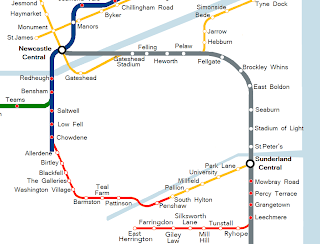
    There is though another option. The following is my proposed Washington route trying to strike a balance between good service and realism.

    Since I'm tending towards the ideal here I will link this route to South Hylton in Sunderland (unlike with my last Washington post) to give Washington ( quick access to both of its neighboring cities; ideally what it needs.
    So. Starting from South Hylton the track goes as follows:

    Penshaw-

    Following a rebuilt Leamside line it makes sense to have a diversion to Penshaw rather than going straight over the Victoria Viaduct, it would be annoying for the Penshawers to have the track so near yet so far.
    It is quite a diversion and so this station is entirely optional, Station Road would seem a smart place for the station though somewhere more north easterly would make the track less of a diversion and if the line isn't following Leamside directly could fit into more of a loop then a turn around.

    Pattinson-


    Not far over the viaduct, just SW of the first ugly big white industrial estate building.

    Teal Farm-

    Right at the edge of the estate, between it and Barmston (which this station could easily be named if not for the name being used elsewhere!) following the Leamside track.

    Barmston-

    The track goes off the Leamside line at the top of the estate and follows the Sunderland Highway westwards with the station being towards the end of the estate.
    By following the highway I mean just what I say.
    Look at a typical large road- they have large green shoulders, often big enough that the motorway they are next to could double its size if further lanes were built on the green shoulders. This is more than enough room for a metro line to follow; right into the middle of town.

    Washington Village-
    This station is perhaps a bit close to those on either side but it seems a logical place with a heavy residential area lying just to the south and Hertburn over the road.

    The Galleries-

    As I've said a Galleries stop is really a requirement with a Washington metro. I would have the station more towards the Washington Highway end of the shopping centre so as to space the station a bit more from the Washington Village one.

    Blackfell-
    This station would be on the opposite side of the A1231 than the others, having crossed a round about near The Galleries and it being just as easy to stay on the other side or cross. As with most of these motorway huggers having easy access from the others side of the road should be required though, which wouldn't be too hard.
    This station again serves a large housing area and a industrial estate (Crowther), I would place it somewhat after the primary school.

    Birtley-
    We've now left Washington and are heading towards Gateshead.
    This station would be on the far north of the town, not in the best place really, but it is only here as we are passing Birtley anyway.

    After Birtley there is a bit of a choice to make.
    The by far easier way involves dashing for the east coast mainline and following that up to Newcastle central.
    The harder route is to try and give Gateshead a more thorough metro service with lots of tunneling, two ways to do this could be:
    1: Durham Road. Cut and Cover. The trouble here is it is a bit close to the railway anyway. Worth the effort? Nah.
    2: Old Durham Road.
    More central and there's also a lot of fields to skip into so its not all underground.
    Construction though would still be very difficult and the reward nowhere near as great as in the main difficult area needing metro service- western Newcastle.

    Overall the conservative route is by far the wiser. We will go to the railway line.

    Allerdene-
    Not such a great place but its en-route to the railway line. Hook close to the town and there you go, just west of Durham Road.
    Its not far north of the angel of the north (400 meters. Think a walk from haymarket station to monument station) which gives a bit of extra purpose to the station I suppose in tourism.

    Chowdene-

    And we've joined the main railway line.
    This station would be a rather important one in serving both the large residential area of Gateshead it is named for and Team Valley- Retail World being around 700 meters westwards and the rest of the huge industrial estate nearby.

    Low Fell-
    Up near the Ravensworth Arms hotel seems a next wise stop.
    Again this serves the Team Valley industrial estate (it is huge) as well as some housing.

    After this we've immediately reached another choice as the track splits in two.
    The first option is to take the more westerly route which we can follow to the previously mentioned Teams station then up to Bensham and beyond Newcastle.
    The second option is to take the more easterly route which would take us straight to Bensham. Here there would be room for another station (which I would name Saltwell) which would give service to a large residential area.

    I would tend towards option 2 here. The main deciding factor I would see being one of whether train scheduling would permit the metro to follow this route.
    As mentioned in the Cramlington extension however extension of the track to add an extra lane or two at least in some places is always an option.

    Ponteland

    One big oddity when looking at the existing metro is the airport line.
    It stretches far to the north west of the city well out of any populated areas just to get to the airport.

    This is somewhat overkill for a airport as small as Newcastle's but fair enough, I have found use for a dedicated and sanely priced airport-city link in the past. As I've mentioned in prior posts this is much better than the situation in many towns where the airport has a monopoly and charges you £10 for a 10km shuttle bus.

    But, the airport line could have been so much more. Just to the west of the airport, a little more than a mile away, lies the large village (10,000 people) of Ponteland. Why is this not connected to the metro?

    The airport line was not built totally from scratch, like much of the metro it was built over what used to be a railway connecting Ponteland and Newcastle. To look at satellite photos you can still clearly see where this line used to be extending north west of the airport to Ponteland.

    So why then does the line definitively end at the airport and not follow to its natural conclusion?
    Politics.
    Ponteland lies outside of Tyne and Wear and in the county of Northumberland. Due to the way the country is organised Ponteland is denied a valuable service linking it to the nearby city where most of its population work.

    If we're to be suggesting ways to improve the metro though then a extension to Ponteland really needs to be done.
    Unfortunatly due to the way the airport station is built continuing directly on from there would be a needlessly difficult process with the airport car park blocking the way. Whether this would be crossed or a new station built though is neither here nor there. The end result should be the same; the addition of Ponteland to the end of the green line.

    Saturday 2 January 2010

    South Sunderland


    One proposal which has been suggested to extend the metro in the future is to Seaham south of Sunderland.
    Now to me this doesn't seem to be the best of extensions; sure the track is already there but Seaham is rather out of the way and rather small being only 20,000 people and 10km south of Sunderland. After Seaham you would then have a similar distance to follow to the 30,000 population Peterlee and after that you've 20km or so until Hartlepool- a large town which is more associated with Teeside than Tyne and Wear.
    This is really far far more territory for trains than the metro.

    However. The route to Seaham would involve some rather good extensions long before it gets to its destination, it is only the final leg which is a bit pointless. To get to Seaham on the Durham Coast Line you must first pass through quite a large amount of southern Sunderland. Now this area needs connecting to the network!
    Sunderland is a rather south heavy city and an extension of the metro service here would really increase use and drastically improve transportation in Sunderland.

    I would suggest at the very least that the metro be extended down to Ryhope, this can be done using already existing lines.

    Further than this however I would then suggest in a ideal situation the construction of some new metro track. Rather than heading south and out of the city to Seaham the line should instead head west, into the outer suburbs of Sunderland.

    In an ideal world this would involve a lot of tunneling, hooking well north into densely built up areas before heading through Pennywell and then linking back up with South Hylton to give a nice 'Sunderland ring'. This though will never happen. Cost unfortunately is an object.

    Instead I propose the following as shown on the image. This proposal would involve little or no tunneling yet still give metro service to the outer suburbs of Sunderland; an important note to add being that one area in which a metro really shows its advantages over busses is with long distances.

    Mowbray Road-

    The first of the new southern metro stations I would place as the railway track crosses the named road. Already we are getting towards a built up area.

    Percy Road-

    This one is really in the midst of a lot of housing.
    My idea of where to place this would be at the end of Matanzas Street and Fuller Road with good access from both sides of the track however anywhere in that area could be a good potential location.

    Grangetown-


    A somewhat less built up area but nonetheless there is a lot of housing and it seems some shops (I am unsure what those white buildings by the line are, I've never been to the area in question).
    Near to Ocean Road would be a wise place to put the station it seems.

    Leechmere-


    This station would be the last of those on the existing track before we loop westwards. This station is quite a distance from the houses unfortunately but it has good beach access!

    Ryhope-


    Rather than the south the north end of Ryhope is my chosen recipient of the next station, there being a plentiful gap of open ground between it and Leechmere.

    Tunstall-

    Yet again we go through a gap, this time a southbound one between Ryhope and Silksworth. The south east of Tunstall seems a wise spot for the next station before we head west again.

    Mill Hill-

    The one difficult part of this track lies here with a big patch of allotments lying between Silksworth and Doxford. Unfortunatly some of those would have to go with the location of the station somewhere towards their south east.

    Silksworth Lane-

    As good a place as any to stop next seems to be as we hook northwards on Silksworth Lane.

    Giley Law-

    After a lot of fields we then come to Giley Law. We need not head into it too much with a station on the north west of the fields.

    Farringdon-

    South south west of Giley Law is the next stop at Farringdon by Silksworth Road.

    East Herrington-

    The final stop of this extension I would place near the Doxford Buisness Park. Here we have a bit of a tight squeeze near the roads but still it seems there is space without demolishing any buildings.


    And there we have it.
    What should be done in southern Sunderland (or at least something roughly like it) rather than a Seaham extension.
    This extension also sets us up well for serving the 10km south west Houghton-Le-Spring (35,000 people) and the surrounding area. Though this would be far more via park and ride or bus and metro combination than a actual extension; though again in an ideal world....

    Shields-Sunderland


    One commonly mooted easy extension is a direct link between South Shields and Sunderland.
    Though in an ideal world this would be done via tunneling right through eastern South Shields and past Marsden and Whitburn this would of course in practice be way over the top for the population in that area.
    The most commonly suggested route, which has been reported in the local press, is what is shown on the map. Reconstructing a dismantled railway alignment just as the track loops to Simonside (coming from Shields), this would then take you to the southern metro track just after Brockley Whins.

    My view on this is rather meh. Its not a very useful or exciting route. You could maybe have one extra station on the extension to give more service to south South Shields however overall it mostly just makes using the metro for Sunderland-South Shields quicker and doesn't actually extend the service.

    This extension though does seem to be one of the most likely to occur with it being actively discussed in the press. Apparently the Metro operators are wanting stabling facilities in the Shields area and this seems to be a good place for them. Hopefully there'll be a station in it too unlike the Gosforth stables.

    Friday 1 January 2010

    To Washington! - Leamside Line


    The second extension I will discuss is the Washington extension.

    Extending the metro to Washington will bring service to a large and totally unserved town. Also I could see an extension to Washington being very politically expedient; people in Washington are paying their taxes and funding the metro just like those in the other towns so why don't they have access to it?

    The easiest way to extend to Washington would be via the Leamside Line.
    The Leamside Line is a railway line which runs from Pelaw down the east side of Washington and then over the river wear at the rather pretty, Victorian-era Victoria Viaduct.

    The Leamside Line has been out of use since 1991, in some places the track still exists however in others it has been removed. It is likely however that even in areas where the track still exists that major maintenance work will need to be performed on the track; total replacement in most places. So all Leamside really gives us is a easy route rather than a ready built track.

    If added to the metro the route would go as follows-

    Wardley-

    Wardley is a rather unfortunate town in that its a bit too big to be totally adequatly served by one station but too small to be served by one.
    West along the line you have a very small gap between station existing, if this rule was followed in Wardley you could get two stations- Wardley Colliery and White Mare Pool.
    Northwards however towards South Shields you get rather big gaps which would make for just one Wardley station.
    Here I am going with just the one, perhaps at the bridge before the Quarry Park stables; the Pelaw station also serves part of Wardley to an extent and to have three stations in this little town would be rather silly.

    Follingsby-

    The Follingsby Industrial Estate was formerly home to a freight station which which was the destination for most of the traffic using the line in its latter years.
    Reopening this as a metro station wouldn't make for one of the more popular stations on the network however people do work in the area and it is spaced such from the others that it is yet another 'we might as well'.
    Given the amount of space in the area perhaps this could be a good place for a park and ride for those working in Newcastle much like the current East Boldon.

    Stephenson-

    The next station will again serve a largely business rather than residential area but again spacing has made it so that this is a logical spot to place a station as we come into Washington.

    Sulgrave-


    After Stephenson the next part of Washington to be passed is Sulgrave and here we finally have a big residential area to serve. As with much of the Leamside line however unfortunatly we're on the far east end of it. Nonetheless a station here would be used a lot, I would place it around the place the A1290 crosses the track.

    Barmston

    Just south of the Sunderland highway would seem the next smart place for a metro station. This would perhaps be the best station on the route being right in the midst of a industrial and residential area.

    Teal Farm-


    Barmston is so big that we can really squeeze in two stations here, this one being at the far south of the estate where it borders onto others including Teal Farm.

    Pattinson-


    The last station in Washington shoudl be around the bend serving the Pattinson area. Again though on the far east of the area it is a rather large area.

    After Pattinson we have a number of choices of what to do next if this route is the one we're following.

    1: End of the line. The metro train then heads back to Newcastle.
    2: Cross the Victoria Viaduct to serve the towns of Penshaw and Shiney Row then go home.
    3: Cross the Victoria Viaduct then after an optional Penshaw visit loop around to join the Sunderland line at South Hylton. Penshaw is quite out of the way and you would get a strange nook nonetheless I think it would be rather cruel to come so near to this town and not actually serve it.

    Additionally if we are to be going up to South Hylton the old Durham-Sunderland line (the route of which is still visible and would be logical to follow) passes through the small village of Coxgreen. This village however I feel is a bit too small to be given its own metro station unless some development is planned in the area; I somehow doubt though that this would be wanted by the residents or done by the council.

    I will be taking the simplest most conservative option her; the entire point of this post being the 'easy' way of connecting Washington. On the picture the colours mean the same as before with the addition of red for the new Washington line.