Showing posts with label Washington. Show all posts

Wednesday, 27 October 2010

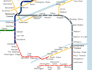
Updated route- Station map


And here are some minor changes to the more traditional metro map.
The major ones from the earlier version are:
[*] A kink in the track in the west end to get to the west edge of Scotswood (where redevelopment is taking place) rather than going straight to Lemington
[*] The blue line follows the yellow line to Byker rather than creating a new station along the mainline just a few metres north of it.

Monday, 25 October 2010

Updated route- Geographic map


Excuse the uglyness of the map with all the random squares taken out of it but it was just too huge to post complete. I've even had to shrink it down quite a lot to get anything working!
Here is my proposed route on a geographic map. The stations are of course shown by the big over-sized yellow and black squares whilst the tracks are their route colours (with different shades for above/below ground).
Its somewhat rough but hopefully it'll give you a idea of the way things should be.
As I said back when I first started this the routes range from hard (the west end) to we should bloody well do this tomorrow (the blue line).

Sunday, 3 January 2010

Washington- Harder but better


The last post about Washington discussed the Leamside route; a route which on the surface of things requires next to no work however it only bypasses Washington on its far eastern side and so would provide less than satisfactory service to the town. I believe that the main reason Washington doesn't currently have metro access is because Nexus will (can?) only follow this 'soft' route and see that it wouldn't give very effective service.

Ideally a Washington metro link needs to go right through the centre of the town. The Galleries area being a logical 'central point' for a Washington line. In an ideal world this would again of course involve lots of tunnels and slice right through the buildings. Of course though this is silly and is never going to happen.

There is though another option. The following is my proposed Washington route trying to strike a balance between good service and realism.

Since I'm tending towards the ideal here I will link this route to South Hylton in Sunderland (unlike with my last Washington post) to give Washington ( quick access to both of its neighboring cities; ideally what it needs.
So. Starting from South Hylton the track goes as follows:

Penshaw-

Following a rebuilt Leamside line it makes sense to have a diversion to Penshaw rather than going straight over the Victoria Viaduct, it would be annoying for the Penshawers to have the track so near yet so far.
It is quite a diversion and so this station is entirely optional, Station Road would seem a smart place for the station though somewhere more north easterly would make the track less of a diversion and if the line isn't following Leamside directly could fit into more of a loop then a turn around.

Pattinson-


Not far over the viaduct, just SW of the first ugly big white industrial estate building.

Teal Farm-

Right at the edge of the estate, between it and Barmston (which this station could easily be named if not for the name being used elsewhere!) following the Leamside track.

Barmston-

The track goes off the Leamside line at the top of the estate and follows the Sunderland Highway westwards with the station being towards the end of the estate.
By following the highway I mean just what I say.
Look at a typical large road- they have large green shoulders, often big enough that the motorway they are next to could double its size if further lanes were built on the green shoulders. This is more than enough room for a metro line to follow; right into the middle of town.

Washington Village-
This station is perhaps a bit close to those on either side but it seems a logical place with a heavy residential area lying just to the south and Hertburn over the road.

The Galleries-

As I've said a Galleries stop is really a requirement with a Washington metro. I would have the station more towards the Washington Highway end of the shopping centre so as to space the station a bit more from the Washington Village one.

Blackfell-
This station would be on the opposite side of the A1231 than the others, having crossed a round about near The Galleries and it being just as easy to stay on the other side or cross. As with most of these motorway huggers having easy access from the others side of the road should be required though, which wouldn't be too hard.
This station again serves a large housing area and a industrial estate (Crowther), I would place it somewhat after the primary school.

Birtley-
We've now left Washington and are heading towards Gateshead.
This station would be on the far north of the town, not in the best place really, but it is only here as we are passing Birtley anyway.

After Birtley there is a bit of a choice to make.
The by far easier way involves dashing for the east coast mainline and following that up to Newcastle central.
The harder route is to try and give Gateshead a more thorough metro service with lots of tunneling, two ways to do this could be:
1: Durham Road. Cut and Cover. The trouble here is it is a bit close to the railway anyway. Worth the effort? Nah.
2: Old Durham Road.
More central and there's also a lot of fields to skip into so its not all underground.
Construction though would still be very difficult and the reward nowhere near as great as in the main difficult area needing metro service- western Newcastle.

Overall the conservative route is by far the wiser. We will go to the railway line.

Allerdene-
Not such a great place but its en-route to the railway line. Hook close to the town and there you go, just west of Durham Road.
Its not far north of the angel of the north (400 meters. Think a walk from haymarket station to monument station) which gives a bit of extra purpose to the station I suppose in tourism.

Chowdene-

And we've joined the main railway line.
This station would be a rather important one in serving both the large residential area of Gateshead it is named for and Team Valley- Retail World being around 700 meters westwards and the rest of the huge industrial estate nearby.

Low Fell-
Up near the Ravensworth Arms hotel seems a next wise stop.
Again this serves the Team Valley industrial estate (it is huge) as well as some housing.

After this we've immediately reached another choice as the track splits in two.
The first option is to take the more westerly route which we can follow to the previously mentioned Teams station then up to Bensham and beyond Newcastle.
The second option is to take the more easterly route which would take us straight to Bensham. Here there would be room for another station (which I would name Saltwell) which would give service to a large residential area.

I would tend towards option 2 here. The main deciding factor I would see being one of whether train scheduling would permit the metro to follow this route.
As mentioned in the Cramlington extension however extension of the track to add an extra lane or two at least in some places is always an option.

Friday, 1 January 2010

To Washington! - Leamside Line


The second extension I will discuss is the Washington extension.

Extending the metro to Washington will bring service to a large and totally unserved town. Also I could see an extension to Washington being very politically expedient; people in Washington are paying their taxes and funding the metro just like those in the other towns so why don't they have access to it?

The easiest way to extend to Washington would be via the Leamside Line.
The Leamside Line is a railway line which runs from Pelaw down the east side of Washington and then over the river wear at the rather pretty, Victorian-era Victoria Viaduct.

The Leamside Line has been out of use since 1991, in some places the track still exists however in others it has been removed. It is likely however that even in areas where the track still exists that major maintenance work will need to be performed on the track; total replacement in most places. So all Leamside really gives us is a easy route rather than a ready built track.

If added to the metro the route would go as follows-

Wardley-

Wardley is a rather unfortunate town in that its a bit too big to be totally adequatly served by one station but too small to be served by one.
West along the line you have a very small gap between station existing, if this rule was followed in Wardley you could get two stations- Wardley Colliery and White Mare Pool.
Northwards however towards South Shields you get rather big gaps which would make for just one Wardley station.
Here I am going with just the one, perhaps at the bridge before the Quarry Park stables; the Pelaw station also serves part of Wardley to an extent and to have three stations in this little town would be rather silly.

Follingsby-

The Follingsby Industrial Estate was formerly home to a freight station which which was the destination for most of the traffic using the line in its latter years.
Reopening this as a metro station wouldn't make for one of the more popular stations on the network however people do work in the area and it is spaced such from the others that it is yet another 'we might as well'.
Given the amount of space in the area perhaps this could be a good place for a park and ride for those working in Newcastle much like the current East Boldon.

Stephenson-

The next station will again serve a largely business rather than residential area but again spacing has made it so that this is a logical spot to place a station as we come into Washington.

Sulgrave-


After Stephenson the next part of Washington to be passed is Sulgrave and here we finally have a big residential area to serve. As with much of the Leamside line however unfortunatly we're on the far east end of it. Nonetheless a station here would be used a lot, I would place it around the place the A1290 crosses the track.

Barmston

Just south of the Sunderland highway would seem the next smart place for a metro station. This would perhaps be the best station on the route being right in the midst of a industrial and residential area.

Teal Farm-


Barmston is so big that we can really squeeze in two stations here, this one being at the far south of the estate where it borders onto others including Teal Farm.

Pattinson-


The last station in Washington shoudl be around the bend serving the Pattinson area. Again though on the far east of the area it is a rather large area.

After Pattinson we have a number of choices of what to do next if this route is the one we're following.

1: End of the line. The metro train then heads back to Newcastle.
2: Cross the Victoria Viaduct to serve the towns of Penshaw and Shiney Row then go home.
3: Cross the Victoria Viaduct then after an optional Penshaw visit loop around to join the Sunderland line at South Hylton. Penshaw is quite out of the way and you would get a strange nook nonetheless I think it would be rather cruel to come so near to this town and not actually serve it.

Additionally if we are to be going up to South Hylton the old Durham-Sunderland line (the route of which is still visible and would be logical to follow) passes through the small village of Coxgreen. This village however I feel is a bit too small to be given its own metro station unless some development is planned in the area; I somehow doubt though that this would be wanted by the residents or done by the council.

I will be taking the simplest most conservative option her; the entire point of this post being the 'easy' way of connecting Washington. On the picture the colours mean the same as before with the addition of red for the new Washington line.